Moab, UT
When we left Cody, we spent one night in Yellowstone to see the area that was closed when we were there before. Then we went south through the Teton Mountains to Boulder, WY, population 48. I had ordered a new motor for our entrance steps to be delivered there.
Not much in that area. We did get the motor and our mail.
Next stop was Sunset, UT. We had to get a new motor for one of out slide-outs installed. Sunset is between Salt Lake City and Ogden. We stayed in the RV dealer's parking lot.

While there, we went to Antelope Island State Park. Antelope Island is the largest island on Salt Lake. Salt Lake is from 4 to 10 times saltier than the ocean, depending on what section.

We left there heading for Moab, UT. After spend one night in a Walmart parking lot, then heading south, we started seeing different looking landscape.

Finally arriving in Moab. The entrance to Arches NP is just across the Colorado river from Moab.

Canyonland NP is 30 miles away. Lots to do and see here.

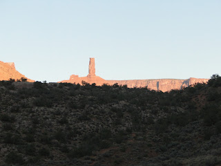
Red mountains here.

Our scenery from the RV while here.
Friday morning we went to an agency to book some activities. We wanted to do a hot air balloon ride but they have quit for the season.
So we booked a sunset cruise with dinner for Friday evening, A 7:30 AM horse back ride for Saturday morning and a Hummer trip for Sunday evening at sunset.
Showed up Friday evening for the cruise and it was canceled due to weather. Rescheduled for Monday. Showed up for the horse back trip, canceled due to grounds being wet from over night rain. Rescheduled for Tuesday evening. They did give us a free breakfast.
We decided to go to Arches NP since we were up and fed.

The road through the canyon to Arches was scenic.

Arches National Park, home to over 2000 arches created over time with water flow

The view back toward Moab.

The first major sight is balance rock.


Then on to Delicate Arch. The best known arch of the more than 2000 in the park

Delicate Arch is the unofficial logo of Utah.

Uh oh, we just drove over this road 10 minutes ago. Oh well, as low as it is, it should be clear in 1/2 hour.

Same road 10 minutes later. Now 4 feet deep. This is not good. No other way out.
We have never seen a flash flood before .
A ranger came to us over a path with a foot bridge. She said it would take approximately 8 hours for the water to go away. It started 20 miles away from the rains the night before.

The rangers brought us food and drinks.

Actually the food was good, better than the old style army rations. There is even a chemical heater for the food. Works good.
They found a bus to pick us up on the other side and take us into town if we wanted to go. Or we could wait it out. There are bathrooms on our side.
We elected to go.
We locked the car and left it there.
Sunday morning we drove the RV back to Arches to get the car.

Same spot as Saturday but less water. It was very slick because of the silt deposit.

The cars over night parking spot.

Then a little more sightseeing. Double Windows.

Finally, great weather, mid 50s at night, high 70s daytime, no rain.
Our Hummer trip got off great Sunday evening. We went to Hell's Revenge, a place that attracts "off-roaders" from all over the country.

Our ride.
The civilian version of the military Hummer is well suited for this kind of terrain.

You can see the snow capped LaSal mountains in the background. The french traders named them because they thought it was salt on the peaks. They were here to trade goods for salt from the Indians.

Our trail up one of the climbs. The cycle rider "flew" down. We went up slower.

If you look close, you can see our trail over several of these big rocks. We actually climbed and went down inclines over 60 degrees.

The Colorado River.

Don't know these people.

The trail we came up on and will be going down after sunset.

Getting ready to go down then back up straight across.

And, this is why we took this very trip, the sunset.
It was starting to get dark when we started back, no moonlight, and at least 45 minutes to get back.
Actually we had to use headlights going back. Lots of the time the lights were not even on the road so we had to rely on the driver knowing where to turn.
It was a lot of fun.

We took a boat trip in a boat similar to this one Monday evening on the Colorado River.

The Colorado River. All the walls were carved over many years by the river.

There are many different looks to the canyon walls.

We saw lots of rock climbers, male and female.

The reflection on the river was magnificent.

Even arches. This one is called Jug Handle.

We haven't gotten tired of this scenery yet.

We even saw a beaver.

And they had a Dutch Oven supper waiting for us when we got back.
On Tuesday we drove out to Castle Valley for a horseback ride. Castle Vally is where lots of western movies were made. A lot of John Wayne movies were made here including Rio Grande. The Colorado River was used as the Rio Grande River.

The entrance to the lodge, ranch and winery. All of the set for Rio Grande was built on this property.

Of course we had to get here in time for some wine tasting.

On to the corrals

Mounted up


And on to the trail. The bridge below is where we came from, under it.
It is a rugged trail.

This is Melissa, our tall, lanky, snuff dipping guide. Something else about her later.

We forded streams

\stopped for photo shoot. From the picture, it is hard to tell if Cathy is having fun.

Went down hill and back up
Castleton Rock, 400 feet above the 1000 foot base. Chevrolet put a car on top for a commercial. Bon Jovi taped a video on the smaller peak next to it.
Oh, our tall, lanky wrangler climbed Castleton Rock twice.


On the way home we had to follow a creek.

We briefly visited the Museum. They have something from all the movies, commercials and videos there.

Thursday, Canyonlands National Park, 42 miles from our campsite.

Canyonlands NP is divided into 2 parts, Island in the Sky and Needles. The entrances are about 85 miles apart and no way to connect otherwise. We will just go to this one.

Island in the Sky is just that. An island surrounded almost completely by canyons. As you drive through, there is one continuous canyon on both sides. This canyon, from one outside wall to the other is wider than the Grand Canyon, though not as deep. They both have the Colorado River flowing through them.

We decided to do a hiking trail to Mesa Arch. It is an arch on the canyon rim.

Mesa Arch, you can see the canyon in the background.

Only a short distance to go. Maybe Cathy will make it. I think she worked of that milkshake we will have when we get back.

The end of the island is Grand View Point. You can see both sides and straight across The Needles. This is as close as the two parts of the park come and it was too far for a decent photo.

Needles is straight ahead.

The Colorado River is straight ahead but we could not see it.

Looking back toward the entrance.

At one time, Uranium was mined here. The Federal Government owned the land and decided to make it a NP so no more mining.. We are glad they did.
We have two more days here and hate to leave. Cortez, CO next, then the Balloon Fest.
This weekend we just chill out.
Not much in that area. We did get the motor and our mail.
Next stop was Sunset, UT. We had to get a new motor for one of out slide-outs installed. Sunset is between Salt Lake City and Ogden. We stayed in the RV dealer's parking lot.

While there, we went to Antelope Island State Park. Antelope Island is the largest island on Salt Lake. Salt Lake is from 4 to 10 times saltier than the ocean, depending on what section.

We left there heading for Moab, UT. After spend one night in a Walmart parking lot, then heading south, we started seeing different looking landscape.

Finally arriving in Moab. The entrance to Arches NP is just across the Colorado river from Moab.

Canyonland NP is 30 miles away. Lots to do and see here.

Red mountains here.

Our scenery from the RV while here.
Friday morning we went to an agency to book some activities. We wanted to do a hot air balloon ride but they have quit for the season.
So we booked a sunset cruise with dinner for Friday evening, A 7:30 AM horse back ride for Saturday morning and a Hummer trip for Sunday evening at sunset.
Showed up Friday evening for the cruise and it was canceled due to weather. Rescheduled for Monday. Showed up for the horse back trip, canceled due to grounds being wet from over night rain. Rescheduled for Tuesday evening. They did give us a free breakfast.
We decided to go to Arches NP since we were up and fed.

The road through the canyon to Arches was scenic.

Arches National Park, home to over 2000 arches created over time with water flow

The view back toward Moab.

The first major sight is balance rock.

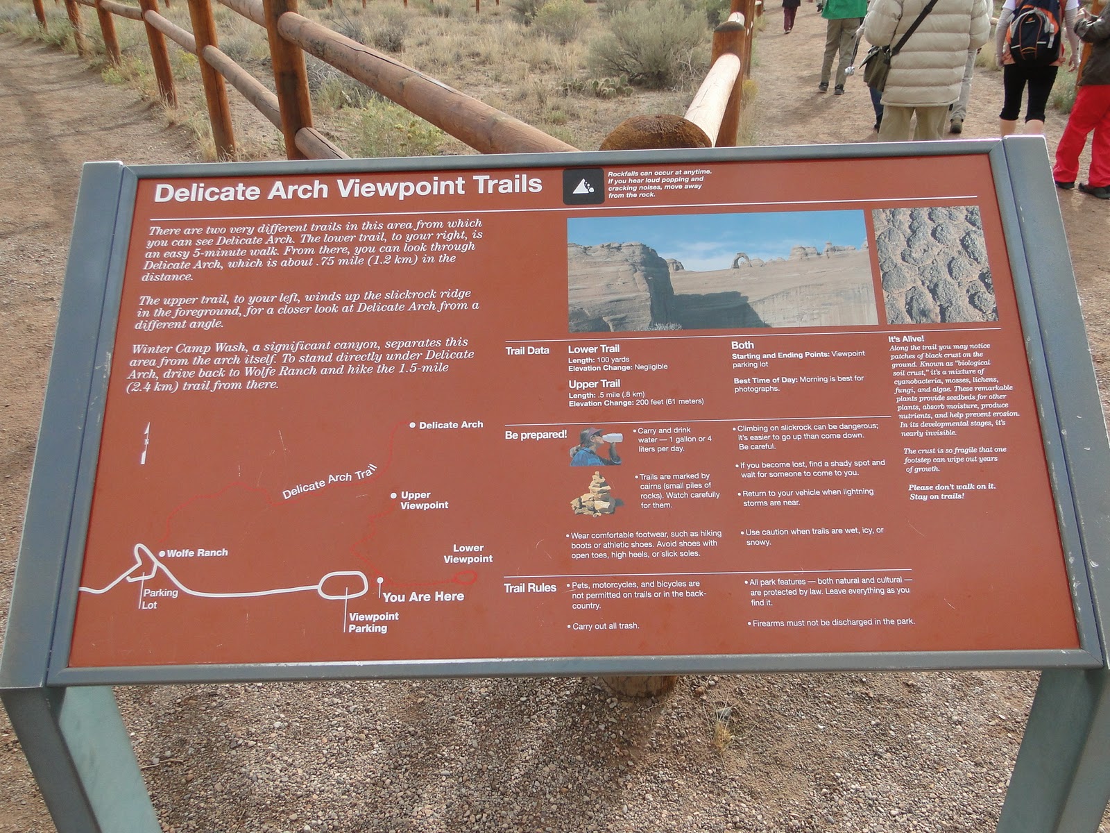
Then on to Delicate Arch. The best known arch of the more than 2000 in the park

Delicate Arch is the unofficial logo of Utah.

Uh oh, we just drove over this road 10 minutes ago. Oh well, as low as it is, it should be clear in 1/2 hour.

Same road 10 minutes later. Now 4 feet deep. This is not good. No other way out.
We have never seen a flash flood before .
A ranger came to us over a path with a foot bridge. She said it would take approximately 8 hours for the water to go away. It started 20 miles away from the rains the night before.

The rangers brought us food and drinks.

Actually the food was good, better than the old style army rations. There is even a chemical heater for the food. Works good.
They found a bus to pick us up on the other side and take us into town if we wanted to go. Or we could wait it out. There are bathrooms on our side.
We elected to go.
We locked the car and left it there.
Sunday morning we drove the RV back to Arches to get the car.

Same spot as Saturday but less water. It was very slick because of the silt deposit.

The cars over night parking spot.

Then a little more sightseeing. Double Windows.

Finally, great weather, mid 50s at night, high 70s daytime, no rain.
Our Hummer trip got off great Sunday evening. We went to Hell's Revenge, a place that attracts "off-roaders" from all over the country.

Our ride.
The civilian version of the military Hummer is well suited for this kind of terrain.

You can see the snow capped LaSal mountains in the background. The french traders named them because they thought it was salt on the peaks. They were here to trade goods for salt from the Indians.

Our trail up one of the climbs. The cycle rider "flew" down. We went up slower.

If you look close, you can see our trail over several of these big rocks. We actually climbed and went down inclines over 60 degrees.

The Colorado River.

Don't know these people.

The trail we came up on and will be going down after sunset.

Getting ready to go down then back up straight across.

And, this is why we took this very trip, the sunset.
It was starting to get dark when we started back, no moonlight, and at least 45 minutes to get back.
Actually we had to use headlights going back. Lots of the time the lights were not even on the road so we had to rely on the driver knowing where to turn.
It was a lot of fun.

We took a boat trip in a boat similar to this one Monday evening on the Colorado River.

The Colorado River. All the walls were carved over many years by the river.

There are many different looks to the canyon walls.

We saw lots of rock climbers, male and female.

The reflection on the river was magnificent.

Even arches. This one is called Jug Handle.

We haven't gotten tired of this scenery yet.

We even saw a beaver.

And they had a Dutch Oven supper waiting for us when we got back.
On Tuesday we drove out to Castle Valley for a horseback ride. Castle Vally is where lots of western movies were made. A lot of John Wayne movies were made here including Rio Grande. The Colorado River was used as the Rio Grande River.

The entrance to the lodge, ranch and winery. All of the set for Rio Grande was built on this property.

Of course we had to get here in time for some wine tasting.

On to the corrals

Mounted up


And on to the trail. The bridge below is where we came from, under it.
It is a rugged trail.

This is Melissa, our tall, lanky, snuff dipping guide. Something else about her later.

We forded streams

\stopped for photo shoot. From the picture, it is hard to tell if Cathy is having fun.

Went down hill and back up

Castleton Rock, 400 feet above the 1000 foot base. Chevrolet put a car on top for a commercial. Bon Jovi taped a video on the smaller peak next to it.
Oh, our tall, lanky wrangler climbed Castleton Rock twice.


On the way home we had to follow a creek.

We briefly visited the Museum. They have something from all the movies, commercials and videos there.

Thursday, Canyonlands National Park, 42 miles from our campsite.

Canyonlands NP is divided into 2 parts, Island in the Sky and Needles. The entrances are about 85 miles apart and no way to connect otherwise. We will just go to this one.

Island in the Sky is just that. An island surrounded almost completely by canyons. As you drive through, there is one continuous canyon on both sides. This canyon, from one outside wall to the other is wider than the Grand Canyon, though not as deep. They both have the Colorado River flowing through them.

We decided to do a hiking trail to Mesa Arch. It is an arch on the canyon rim.

Mesa Arch, you can see the canyon in the background.

Only a short distance to go. Maybe Cathy will make it. I think she worked of that milkshake we will have when we get back.

The end of the island is Grand View Point. You can see both sides and straight across The Needles. This is as close as the two parts of the park come and it was too far for a decent photo.

Needles is straight ahead.

The Colorado River is straight ahead but we could not see it.

Looking back toward the entrance.

At one time, Uranium was mined here. The Federal Government owned the land and decided to make it a NP so no more mining.. We are glad they did.
We have two more days here and hate to leave. Cortez, CO next, then the Balloon Fest.
This weekend we just chill out.


Comments